At 1830 hours, after ten days of transit to one of the most remote parts of the world, Falkor arrived to her momentary destination. Science took the wheel immediately and high resolution images began populating the Control Room monitors. By 2300 hours Jonathan Tree, Marine Geologist, had just come down from the bridge. Rubbing his eyes he pronounced “I wasn’t expecting to be making these decisions so early in the process.”
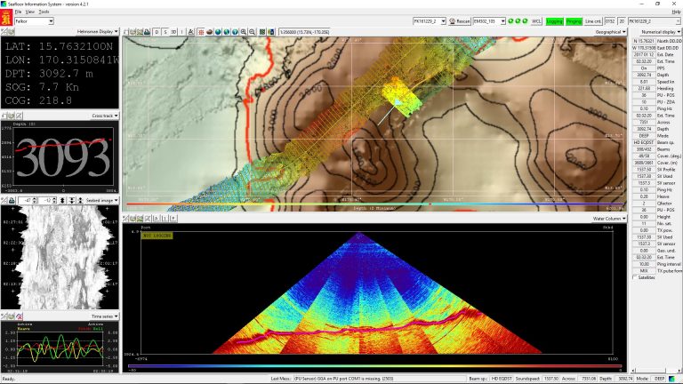
Based on satellite maps, Chief Scientist John Smith determined the optimal location to initiate the mapping survey. The challenge lies in how satellites estimate where underwater volcanic mountains might be located. This is achieved by detecting slight changes in the distance between the satellite and the surface of the ocean, which is ever so slightly bulged up due to water piling directly above the seamount, sometimes predicting the location about 1 km from where it actually lies. When Falkor’s pings began bouncing back from the seafloor to paint the picture of the geological structures, Jonathan realized they were mapping beyond the desired 4500 meters of depth, and not in the target mapping depths of the survey, as the original plan intended.
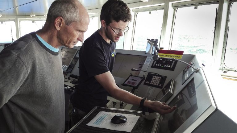
A speedy meeting on the bridge with Captain Heiko Volz and Second Officer Oliver Hurdwell followed, and the best course of action was determined. Currents, wind, weather and optimization of the ship’s time were all considered. Slowly, without compromising the data collected by leaving any gaps in the multibeam’s swath, Falkor began turning and changing course in search of the elusive seamount. “This has certainly been a jump into the deep end for all of those who haven’t mapped before” said Jonathan smiling, “I’m actually having a great time.”
Got It!
A few minutes later, the colors in the maps began changing, which reflected a change in water depth. Sure enough, the seamount began making its debut. “We should call the Bridge and let them know,” said Andrew Kang, Biology student from the University of Guam. “Wait a minute, I’m sure they have it,” responded Jonathan. As if the Officers driving Falkor had heard him, the ship began following the contour of the seamount.
They might make it look easy, but it does take practice. “It is a slow-paced task, but if you get it wrong and turn too fast, Falkor’s 2000 tons take time to come back,” shares Oliver Hurdwell while adjusting numerous controls on the bridge’s console. Time and efficiency are large concerns during any research expedition, but to Oliver communication is the biggest challenge. Experience has taught him how to better communicate with scientists in order to understand what they are looking for, and therefore the best way to get it.
Satellites may offer clues and scientists might draw lines and plans based on educated guesses, but Oliver knows the ocean tends to have other plans. Not only was he unsurprised by the need to chase an underwater mountain, he expected it. Perhaps this is why Jonathan enjoys mapping with Falkor’s crew so much.
Knowledge and Seamanship
The combination of intellectual and physical challenges drew Oliver to become a sailor in the first place. After working on different kinds of vessels, he is now convinced there is a ship for everyone, depending on each sailor’s vocation. Falkor has offered him an interesting learning curve: “On a research vessel, it is not only interesting to see what you can learn and find, but you really get to experience good seamanship,” he says while maneuvering the ship, making sure that the latest turn doesn’t affect the scanning of the seafloor.
He does this as John Smith, Chief Scientist, visits the bridge to discuss the plan for the next few hours: This carefully devised strategy will hold only until the ocean deals its next card. When scientists and sailors come together to map the deep end of an unexplored corner of our planet, they learn to expect the unexpected.