Greetings from the R/V Falkor in the northern Tasman Sea. My name is Alysha Johnson, and I am a PhD student from the University of Wollongong studying the evolution of volcanic islands. It may be natural to ask, “What on Earth am I doing out here in the Tasman Sea? There are no volcanic islands out here.”
There may not be volcanic islands, but there are seamounts and guyots below us, submerged below the water!
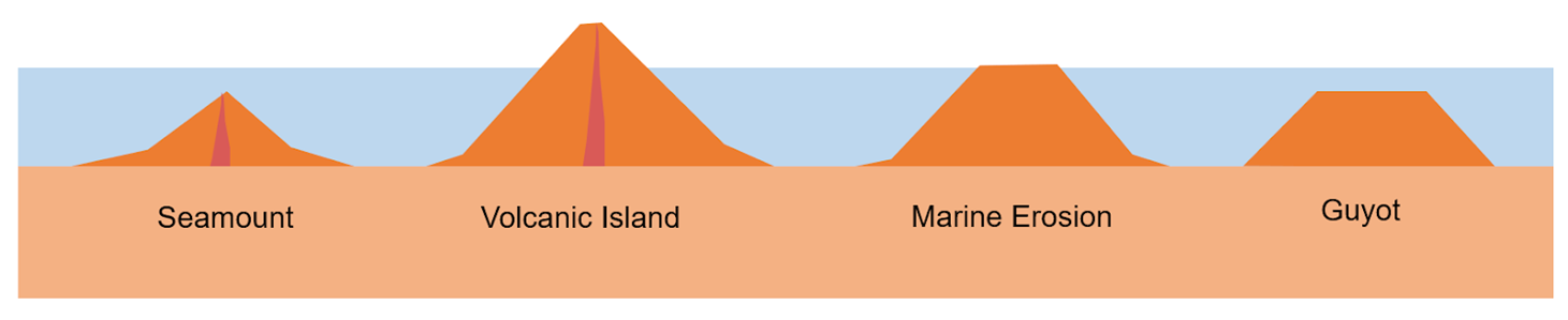
When volcanoes form on the seafloor, they build up over time as they erupt volcanic lava that cools to become basalt. If a volcano does not reach the surface of the ocean, it is called a seamount. If a volcano grows in height and volume enough to reach the ocean’s surface, it becomes a volcanic island (like the islands of Hawaii).
But as soon as a volcano breaches the sea surface, waves and other sub-aerial processes (wind, rainfall, weathering) will cause erosion of the volcano. Over time, these processes will erode the flanks and top of the seamount/island, eventually forming a flat shelf to form a guyot. Compared to the peaked shape of seamounts, guyots have a flat top like a table. All guyots will have been a seamount in the past, but not all seamounts will become guyots.
We are currently mapping a deep basin and a north-south chain of guyots and seamounts in the Tasman Sea, called the Tasmantid Seamount chain. We have just completed mapping the Recorder Seamounts offshore Fraser Island. These volcanoes are part of a >2,400 km long chain of volcanoes that erupted between 56 and 7 Million years ago as the Tasman Basin drifted north over a stationary hotspot. As a result, the seamounts at the north of this chain are the oldest, while those farther south are younger. These volcanoes have erupted along the extinct mid-ocean ridge, transform faults and fracture zones of the Tasman and Coral Seas, taking advantage of weaknesses in the ocean crust from the formation of these seas.
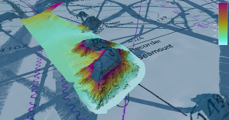
Many seamounts within this chain have flat tops, indicating that they must be guyots. However, as the Tasman Basin subsides, the guyots summits that previously were at the sea surface are now deeper than 400 m below the sea surface. Understanding these guyots’ shapes (their geomorphology) may allow us to understand what processes affected these volcanoes in the past, and what modern volcanic islands may look like million years into the future.
Ecologically, these seamounts provide a hard substrate for marine organisms such as deep-sea corals and sponges to attach. The seamounts provide vital habitat for marine invertebrates like brittle stars and squat lobsters to live on and act as nurseries for deep-sea fish.
The seamounts also influence the flow of deeper waters, which results in the upwelling of nutrient-rich waters towards the sea surface. Upwelling increases the biological productivity of plankton and fish, which in turn provides food for sea birds, larger fish, whales, and dolphins. For our current voyage, we’re fortunate to have our expert seabird researchers to record daily observations of this marine life above and around the seamounts of the Tasman Sea.