Yesterday, Falkor crossed the frontier between Fiji and Tonga, en route to the Niua Volcanic Complex at the very northern tip of Tonga. The “border” between Fiji and Tonga is a line in the ocean about 275 miles from the port of Suva and passing between some of the most remote volcanic islands in the oceans. Because of their dominion over such widely scattered islands, the Exclusive Economic Zones of the two countries are vast. Together they encompass more than 2 million square kilometers, placing them among the top 10 maritime states, with Canada, the United States, Australia and Russia.
The Kingdom of Tonga occupies the southwestern part of the Pacific region of “Oceania”, 1000 nautical miles from New Zealand and more than 1800 miles from Australia. It consists of more than 150 volcanic islands that span an area comparable in size to Texas and larger than most countries in Europe. But Tonga is a “water world” − only 750 km2 of its 700,000 km2 territory (about 0.1%) are above the water line. Most of the 100,000 inhabitants live on the southernmost island of Tongatapu in the capital city of Nuku’alofa.
")
The Kingdom of Tonga occupies the southwestern part of the Pacific region of “Oceania”, 1000 nautical miles from New Zealand and more than 1800 miles from Australia. It consists of more than 150 volcanic islands that span an area comparable in size to Texas and larger than most countries in Europe. But Tonga is a “water world” − only 750 km2 of its 700,000 km2 territory (about 0.1%) are above the water line. Most of the 100,000 inhabitants live on the southernmost island of Tongatapu in the capital city of Nuku’alofa.
Unlike many island nations in the South Pacific that are threatened by the encroaching sea, Tonga has been emerging from the oceans faster than sea level has been rising. Thanks to plate tectonics and the relentless push of the Pacific plate into the Tonga Trench, the islands of Tonga are literally being lifted out of the water. The oldest islands consist of ancient limestone and reefs that are now on land, exposed above sea level by the colliding plates. Many of the raised reef complexes that fringe the islands form near-vertical sea cliffs up to 70 m above the waves.
The same tectonic activity that keeps Tonga above the water line heats the underlying crust and gives rise to prolific volcanism, and new islands are being born out of the volcanic unrest. They are distributed along a line or “arc” in the ocean extending for more than 800 miles from Samoa to the northernmost islands of New Zealand (Figure 1). This is Tonga’s “volcano nursery”.
In the last 100 years, as many as 15 large volcanoes have erupted on the islands, and far more have erupted under wate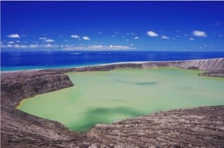 r. Several of the submarine volcanoes have emerged from the sea within the last 10-15 years, with spectacular consequences. The most recent eruptions have occurred in places like Metis Shoal (2001), Home Reef (2006), Tafu-Maka (2008), west Mata (2009), and most recently at Hunga Ha’apai (Figure 2), located just north of the capital of Nuku’alofa.
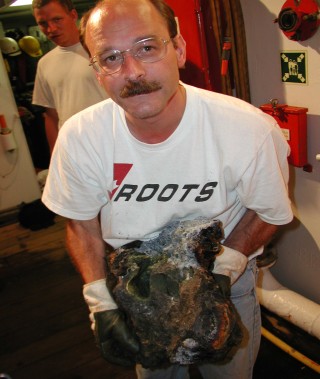
At least 50 large volcanoes also are known to have erupted in much deeper water along the Tonga-Tofua Volcanic Chain. One of the most recent additions is the Niua Volcanic Complex, at more than 1200 m water depth. Falkor and the Remotely-Operated Vehicle (ROV) ROPOS will be exploring a large crater very similar to that which formed on Hunga Ha’apai last January (Figure 2). There, we hope to gain a better understating of the impact of such eruptions on the water column and on the submarine life at the volcanoes while the volcanic vents are still hot.
A daily Haiku from John Johnson:
The ship gently rocks
O’er waves it rises and falls
Ugh not feeling well