After a seemingly endless time of planning, our Virtual Vents cruise is now under way. Falkor has left the port of Suva, steaming ahead northeast towards the Niua Volcano and its southern hydrothermal field in about 1,400 m depth, a day’s travel west of Samoa.
The reason we call it the Virtual Vents cruise is because for the first time, we will attempt to digitally scan an entire black smoker field at the same detail you 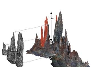 would grasp if you took a casual stroll across this strange landscape. A centimeter in most areas, down to a few millimeters in certain spots of special interest – only you cannot take that stroll. We are driven by the frustration of seafloor scientists who may spend their entire career without ever visiting the place of study. The ocean is deep in many places and the robots we use create all but an incomplete picture of that world. Scientists and the public alike struggle to interpret the flat, two-dimensional videos and photos that remotely operated vehicles send up.
Taking the next step…virtually
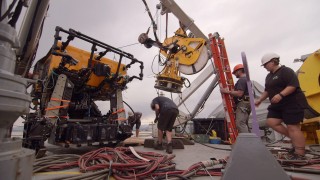
To move the technology further, we mount a range of sophisticated cameras to ROV ROPOS to image the entire vent field. Think of these cameras not as a means to capture tourist memories but as highly accurate, precisely tuned measurement devices, which, in concert, produce a seamless coverage with no gaps. If everything works out as planned, Niua South will be transformed into one of the most photographed places in the oceans, with the projected image count well over a million.
These images are then transformed by Falkor’s high performance supercomputer, Nebula, into a three dimensional terrain model, a map with a photographic texture in full color. This works similar to how we see the world with our two eyes in three dimensions, only here the computer “sees” the world and works hard to make a sense of it. The results of using photos instead of sound waves are much more precise and rich in detail. This allows scientists to plan their sampling campaigns with greatest efficiency, as we only have to go to places that look promising and do not pick up any next best rock or animal for fear a better one might not come along an unknown dive track. So, in a way, we hope to make the well-established methods a bit better, but certainly more effective to carry out at sea. Most importantly, researchers now have all the time in the world to freely examine this virtual copy of the seafloor from the comfort of their offices, not having to count the precious time at sea by the minute.
Virtual data collection
Another way in which this cruise is virtual is in the way we gather the data. When you run an acoustic multibeam survey, you can see the map build up because a rough processing and 3D projection is done in real time. Until now, this has not been available for photography, but on our cruise we will test two independent methods of creating three dimensional point cloud models in real time as we expand our survey. This way, we will be able to recognize if we leave gaps, saving time and money trying to fix our work after we have processed it.
The third and maybe most impressive way in which we are virtual is that we gather high resolution 4k UHD video with wide angle optics that allow images to fill the entire human field of view at once. This specially formatted video is transmitted to the surface over a dedicated optical data line and is remapped to be viewed using immersive head mounted displays. We even stream this exciting imagery live on the Internet (stay tuned for dive announcements). Just turn your head left and right and experience the seafloor as if you were catching a ride on the front of our diving robot!
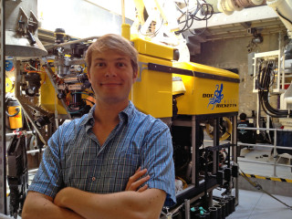
The best technology is worth nothing if the information it provides is not properly put into context of what we already know and do. Therefore, we are joined by our colleagues from the fields of geology, biology and water chemistry to demonstrate that all scientific disciplines can benefit if they work together on the basis of a really, really good map.