Based on work so far, the team is reasonably confident that deep water’s main path into the Juan de Fuca Strait and the Salish Sea is the Juan de Fuca Canyon.
But figuring out what’s happening on the continental shelf west of Vancouver is proving a more vexing question. Data to date haven’t supported the idea that Tully Canyon is the major path onto the shelf for the lower-oxygen upwelled waters, but there are now hints of another possibility.
Upwelling typically involves strong winds blowing parallel to a coast and pushing surface waters away, which causes deeper, colder waters to move upward to fill the void created. The team has been tracking how those deeper waters make their way toward shore, but today they’ve been thinking about a different, related process.
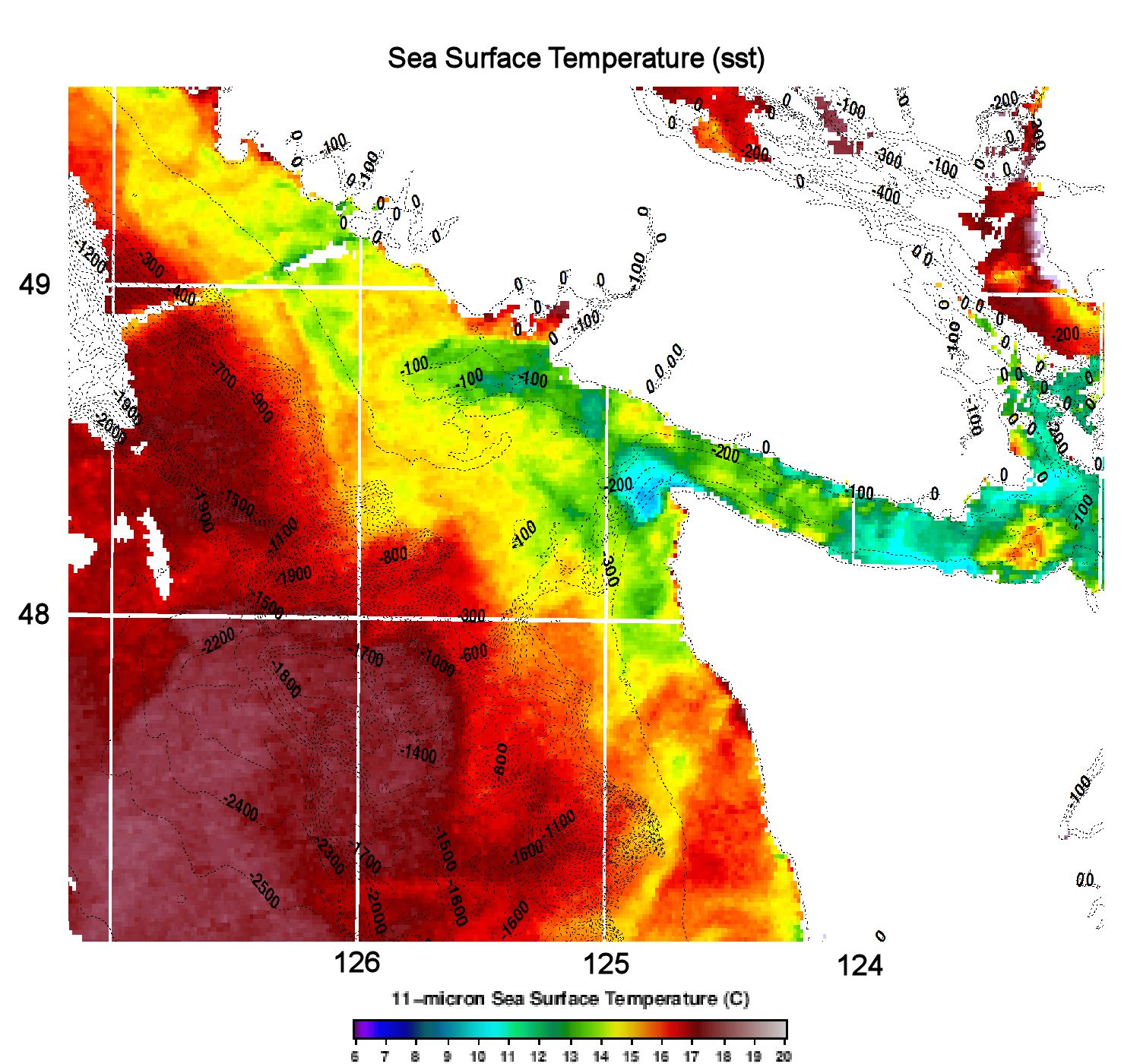
Upwelling creates a seemingly strange situation where warmer coastal water moves offshore, while colder water comes in toward shore. Some of this plays out at the surface, some deeper. The image on the right shows surface waters, with the red indicating the warmer water, and the cooler waters shown in yellows, greens, and blues. The line between colder and warmer more or less follows the line of the continental shelf. This sets up a front where the colder and warmer waters meet, fueling creation of what becomes the California Current, in a fashion similar to how atmospheric fronts create winds.
The California Current moves south toward California, of course, but nothing in the ocean is ever simple. Not all the water at the frontal boundary makes it south. The team is looking for those complications—places where some of the water in this front might be “leaking” to the east onto the shelf.
Getting Spicy
There are a number of ways that researchers try to spot such movements, which can be a complicated process because all the different types of water are mixing and changing, making them harder to spot. One technique is to map out the temperature vs. salinity of the water studied as a sort of signature, because waters that originate offshore are colder and saltier, while coastal waters will tend to be warmer and less salty. So even if you get mixing, you can still spot differences. As a takeoff on a term that’s been used elsewhere, the team is referring to the colder, saltier offshore waters as spicy. So they are looking for spots on the shelf that are a bit spicier, as a clue to the paths of upwelled water.
Analyzing temperature vs. salinity data from the cruise, Susan Allen noticed that there is a hint of a break in that frontal current at an as yet unnamed ridge that rises up and forms the west wall of Tully Canyon (roughly parallel to Vancouver Island), making some of the shelf water spicier.
The current hypothesis is that this ridge shaves off a piece of spicier water from the front, diverting it toward Vancouver Island’s shelf. If this idea is correct, then Tully Canyon itself may not be as important a conduit for upwelled water to the shelf as previously hypothesized.
At midnight tonight, the team will begin a Moving Vessel Profiler survey near this ridge to test the idea. So, check back in tomorrow, and we’ll let you know what they’re finding.