The term Saildrone brings to mind images from opposing ends of the human timescale: sailing – one of the oldest modes of travel – and drones – arguably the most rapidly evolving industry in modern transit.
In a nutshell, this juxtaposition is the exact function and purpose of a Saildrone—combining the efficiency and sustainability of sailing with the latest technology of autonomous vehicles in an effort to collect data from the far reaches of the ocean. Three weeks ago, a Saildrone crossed a patch of the Pacific Ocean at the 30-degree latitude line and relayed a message across the world to report a significant drop in salinity. Our science team received it, and set a course to follow a similar path. Now we have arrived in roughly the same spot: the Subtropical Front.
Lines in the Water
We know this area of the ocean is characterized by a rapid variation in salinity, but we do not know how far it extends. To find the boundaries, the science team plans out a transect, beginning 20 miles north of where the sail drone detected a salinity gradient, and finishing 20 miles south of where we are estimating the boundary ends.
We begin by deploying a CTD cast at ten-mile increments to collect surface data, which immediately shows we are right on target – in the middle of the Subtropical Front.
“We nailed down the front at the same location with the same characteristics we expected from the data,” says Igor Belkin, a physical oceanographer who has been studying oceanographic fronts for over 40 years. “It confirms our entire planning process was done correctly.”

In the Science Control Room, the oceanographers keep a close eye on the data coming in. On the fourth cast, a sharp drop in salinity tells us we have crossed over the edge of the front.
“We know roughly where the front is, but we don’t know its orientation,” Francisco says. “So, we have some options. We can take a circular path but that would take a lot of time. Instead, we’re turning north.” Two hours later, I check in at the Science Control room again, asking when we will deploy the next CTD. It turns out it might be a while. Our turn northeast has veered us away from the front. To get back on track, we are now heading towards the point of the first CTD cast.
Just the Beginning
Later in the evening, the team gathers in the library, and Chief Scientist João Borges de Sousa reviews the events of the days. “The good news is we have found the front, and it is stable,” he says. “We got some good data, and I think everyone has been working together in a very nice way.” After the meeting, half of the team heads to bed, while six people stay awake through the night, keeping a close eye on the salinity measurements, and beginning to analyze the water samples coming from the Rosette profiles.
By Friday morning, we have completed three transects to help us determine boundary lines of the front. “We have the big picture,” Renato says. “Now we want to know more details, in high-resolution.”
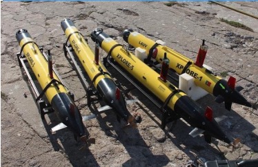
That means it is time to bring out the AUVs.