Many decades ago, a young Les Watling walked on the mountains of his native Canada, collecting ancient fossils weekend after weekend. The fossils represented all kinds of marine groups, which is why – even if the coastline was nowhere in sight – he felt the ocean began calling for him. Fossils were very interesting, but what Les really wanted to do was to see some of those specimens (or at least their descendants) alive and up close. That curiosity has taken him to every ocean but the Arctic. Today, Dr. Les Watling is leading an interdisciplinary team of scientists to a faraway area in the North Pacific, to study biodiversity distribution along the Emperor Seamounts, looking at them closer than anyone has ever looked before.
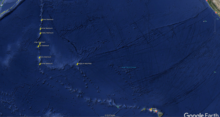
“The reason why we’re going to the Emperor Seamount Chain is because it’s the only area that joins the very northern end of the Northern Pacific with the central part of the Northern Pacific,” Dr. Watling explains. In this part of the ocean, the deep corals along the Aleutian Ridge are completely different from the corals along the Hawaiian Ridge, and the resident scientists want to know why. “There are no other seamounts in the North Pacific that join those two areas together, only the Emperor Seamounts,” he says, “so this is the one chance that we have to find out where the boundary between these two different biogeographic regions actually is.”
A Long Way Away
The location is remote, which is why Dr. Watling knows this is a once-in-a-lifetime opportunity. “This cruise pushes the limits of Falkor’s endurance. The workstations are far away from where we’re based out, which is Honolulu,” shares Jason Garwood, the Captain of our research vessel. It will take the ship nine days of continuous steaming to get to the first seamount, which is 2000 nautical miles from where the ship first sailed. “It is a fun challenge, we have to keep an eye on a lot of things,” says the Captain. “We’re not close to port so if something should happen we have to look at other places where we’d have to go, which is why I know that Kamchatka will be our nearest point of land.”
Because they are is so difficult to get to, there are no high resolution maps of the Emperor Seamounts, let alone ROV explorations in the area. The only bathymetric images of this part of the ocean come from satellite altimetry. Much like the pings emitted and received by the ship’s sonar, satellite altimetry measures the time taken by a radar pulse to travel from the satellite antenna to the surface of the ocean and back to the satellite receiver. Combined with precise satellite location data, altimetry measurements yield sea-surface heights. Once the measurements are blended with the data acquired by several satellites, the geological features on the seafloor can be estimated based on the water displacement on the surface. Basically, the water level will be higher wherever there is a big seamount underneath it. Those are very impressive and certainly useful calculations, however they can never show the seamounts in the level of detail necessary for scientific research.
Once Falkor arrives to its distant destination, its multibeam will render the first high resolution maps of the seafloor. The researchers will then be able to determine the most valuable spots to explore and to send ROV SuBastian into action. For the first time ever, human eyes will look closely at the communities that have colonized these seamounts.
A Fresh Look
Up until now, the specimens collected from this part of our planet have been dragged out of the seafloor by trawls. The first Hawaiian species trawled were described as early as the 1900s. It is because of specimens collected in this manner that scientists know that species in the Aleutians area are very different from those in the Hawaiian area. “What we know so far is that the deep coral fauna in the Aleutians seamounts is made up primarily of smaller colonies, such as little fans. They represent a small number of coral families,” explains Dr. Watling. “When you get to the Hawaiian Ridge, you can actually find colonies that are much larger, big bushes, tall, spirally whip creatures. A whole variety of different kinds of corals and many more species – at least many more families.”
Corals are known as ecosystem engineers: they are capable of building their own habitat and the habitat for other fauna. By understanding why these corals are distributed the way they are along the Emperor Seamounts – located just between the Aleutian and the Hawaiian areas – the scientists will take us a step closer to understanding how our oceans work, and where the boundaries of these biogeographic zones lie.
While Falkor continues covering the great distance towards its destination, Dr Watling makes sure his team is taking advantage of every minute getting ready for the ambitious schedule, designing a strict choreography that will enable them to retrieve samples and document observations from SuBastian as soon as it comes back from each one of its dives.
The years have not weakened Dr. Watling’s curiosity about the secrets of the ocean. “I’m very excited,” he says. “You can see, I’m not too young anymore, but here I am: still doing it.” Dr. Watling has had the most spectacular career he could have hope for, “not too bad for a mountain boy, not too bad,” he laughs before reflecting, “Actually now I’m working on mountains under the ocean… so I guess it all fits.”