The seamount chain now known as the Emperor Seamounts was first named the Northwest Pacific Ridge by Professor Tayama of Tohoku University in 1952 for a long feature in Japanese Bathymetric Chart 6901. In 1953, the American geologist Robert Dietz was invited to Japan on a Fulbright scholarship to describe the features in the same Japanese chart 6901. Dietz published his results in 1954, naming that same elongate feature the Emperor Seamount Chain, and he gave nine of the seamounts names of Japanese rulers who reigned from the year 200 to 1912. No reasons were given for why the particular sovereigns were chosen.
During this cruise we plan to visit as many of seven of the named seamounts. From north to south these are: Suiko, Yomei, Nintoku, Jingu, Ojin, Koko, and Kimmei.
Suiko is a very large seamount, located at 44°35’N, 170°20’E. It has a summit that is about 40 km wide and 100 km long, and reaches its shallowest point at about 950 m. This seamount was named for Empress Suiko, the 33rd sovereign who ruled from 593 to 628. She was the consort of the 30th Emperor and took over after being appointed by the Great Imperial Chief Soga Umako. Suiko proclaimed Buddhism as the state religion, established a system of merit-based promotions based on Confucian qualities, adopted the first official calendar, and established the first moral code for officials. Suiko seamount was also the site of a successful borehole drilled by the Deep Sea Drilling Project. The cores obtained showed that Suiko was an island about 60 million years ago with central lagoon and tropical fern-like vegetation such as maidenhair and other ferns (including tree ferns), but with time it has eroded and subsided to its present position about 1000m beneath the surface of the sea.
Yomei seamount, located at 42°20’N and 170°25’E, with a summit crest at about 915m was named for the 31st Emperor who ruled from 586 to 587. In his second year he became ill, converted to the Buddhist faith, and died soon after. His short reign was marked by plots to rebel by his half-brother.

Nintoku seamount is a large and complicated structure, located at 41° N, 170° 35’ E, with a flat summit that is approximately 25 km wide and 130 km long. Nintoku was the 16th Emperor, son of Ojin, who ruled from 395 to 428 (or 313 to 399; these early dates are uncertain). He was a very progressive ruler. One day, seeing there was very little smoke from the cooking fires of his subjects, he realized how little food they had and decided to free the people from paying taxes for three years. The palace fell into ruins, so taxes were levied again once the people had become prosperous. As a result of this benevolence, Nintoku was given the posthumous name “Benevolence-Virtue Sovereign.” Nintoku also oversaw the first large engineering projects, especially to control flooding, and built for the first time a government ice-house.

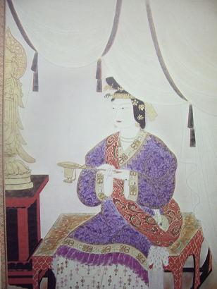
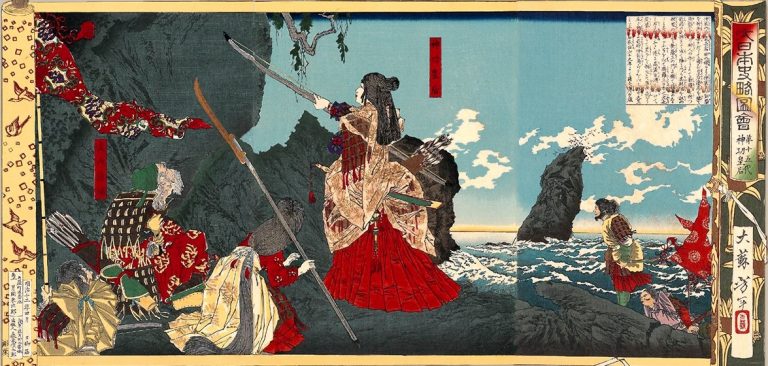
Jingu seamount is located in the Main Gap of the seamount chain at 38° 47’ N and 171° 07’ E. It is a relatively small feature, being 10 km in width and 45 km long. Jingu was the Empress of Emperor Chui – she took over after the Emperor was killed in battle and ruled from 201 to 269 (or 362 to 380). She lead a victorious conquest of part of Korea, defeating the King of Silla, and then returned to Japan to bury her husband and give birth to her son, Ojin.
Ojin seamount is also in the Main Gap, at 38° N and 170° 40’ E. It is slightly larger than Jingu at 20 km wide and 65 km long. Son of Emperor Chuai, Ojin was crowned Emperor in 380 and reigned until 395 (alternate dates are 270 to 310). During his reign, literature from China was introduced into Japan.

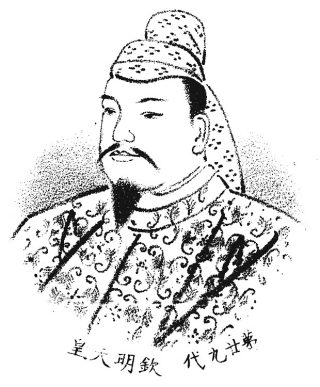
Koko is a very large seamount, located at 35° 25’ N and 171° 30’ E. It is 55 km wide and 130 km long. This seamount is one of the shallowest, reaching 260 m water depth on the summit. It was also the site of a very intensive fishery for pelagic armourhead during the 1970s. In all, about 800,000 tonnes of this fish were removed from the shallow seamounts extending from Koko to Southeast Hancock seamounts – all located at the bend junction of the Emperor seamounts and the Northwest Hawaiian ridge. Koko was the 58th Emperor and ruled from 884 to 887. He re-established falconry and was well remembered for his poetry. He had four imperial consorts and 41 sons and daughters.

The southernmost seamount that we hope to visit is Kimmei (sometimes spelled Kinmei), located at 33° 41’ N and 171° 30’ E. It also a relatively shallow seamount, with a summit about 15 km wide and 50 km long. Kimmei ruled from 540 to 571. Buddhism was officially introduced into Japan during his reign. Unfortunately a serious epidemic broke out shortly after a statue of the Buddha was accepted as a gift. The statue was blamed and was thrown into the canal at Naniwa and the temple constructed to house it was burned. The reign of Kimmei was marked by continual conflict with the Kingdom of Silla in Korea.