Research expeditions are like marathons. Preparation for them is exhaustive and requires extremely disciplined individuals following a careful schedule in order to reach their goals. Once the day arrives, determination is key and keeping the pace up is fundamental.
Yet ensuring the success of an expedition goes far beyond the effort that scientists and experts put into gathering the best data possible. Making sure that a Research Vessel like Falkor is able to provide researchers with everything they need to complete their studies is of the utmost importance.
Ships are self-contained little cities where everyone plays a fundamental role. Therefore, every berth space is very valuable, and each goes only to individuals who have been carefully considered. Once an expedition sets off, these individuals work tirelessly as a team, night and day, to keep this amazing “machine” going, making sure experts are able to concentrate purely on their job. Ironically, this intense rhythm of work can sometimes mean that the crew is not fully aware of the groundbreaking science happening onboard.
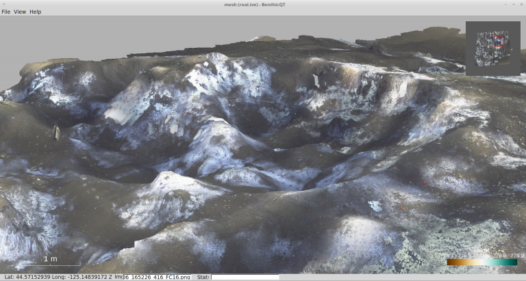
The Adaptive Robotics expedition is particularly engaging, not only because of its intensive use of imagery, but because of the speed at which these images are being processed and rendered into 3D maps that show the seabed with astounding clarity. Once the Falkor crew is presented with these maps, their reactions leave no doubt of just how powerful and useful this technology is.
Not Over Yet
Unlike marathons, once an expedition is over, the work is not done. Researchers go back home carrying huge amounts of data, which they then need to process and make sense of – which usually takes long periods of time. The engineering team onboard Falkor is striving to accelerate data processing so trustworthy information comes in at cruise-relevant time cycles. “We’ve come here to deploy multiple robots, but also to look at ways in which we can make the best use of them. In order to do that we are focusing on the data they collect, between the cycle of deployments, and then using it inform the next dive so we can get the best information of the most relevant places,” explains Dr. Blair Thornton, Chief Scientist.
When Navigator Officer Marissa Judkins pays a visit to the Dry Lab, she is stunned by the representations of the ocean’s floor right underneath Falkor. “The most interesting thing that I have seen so far is the processed imaging from AE2000f and the Tuna Sands. The scale and resolution of these images is really incredible,” she says while looking at a 600 meters by 500 meters map created during the cruise by the AUV AE2000f (a substantial area of the seafloor to acquire and process in such a short period of time). “I think it definitely helps to engage the crew and make us part of the scientific discoveries, which is a part of the job that I love,” says Marissa. “So often when we go home after the cruise and we tell our friends about our expeditions, they ask about the conclusions – a number of times we’re not able to give a concrete answer yet. This time we will be able to go back and tell them, instead of finding out in six months time.”
No Surprises
The hydrate fields that are being surveyed by the robots offer a very unstable environment. Gas is trapped inside pockets of “ice” (the hydrate), and when the hydrate melts and releases the gas, huge holes are created on the seafloor. It is a very rough terrain and it is very hard to predict.
“Another aspect we have to be careful of is the amount of scientific gear on the sea floor. We have to be very careful not to disturb the day-to-day observations being made in this area by these delicate scientific instruments,” says Dr. Thornton.
The invaluable information provided by the scouting robots makes the life of ROV SuBastian’s pilots much easier. For Adam Wetmore, lead of the ROV team, the relevance of this technology for both researches themselves and the ship’s officers and crew, is very apparent. “These scientists are awesome, we really enjoy working with them. If anything, they are helping us. Their maps are so detailed and they can really give us good directions on where to go and what to expect on the bottom,” he says. “Even getting so granular assaying: ‘Hey, we are going three starfish ahead.’ In the past, we had mapping images which would give us an idea of what the bottom looked like, but to be as specific as rocks and minuscule features – we never had that experience before. For all the pilots and everybody involved, knowing what to expect on the bottom, if there are any hazards and what we should be watching out for, is pretty cool.”
Out of Sight, Out of Mind
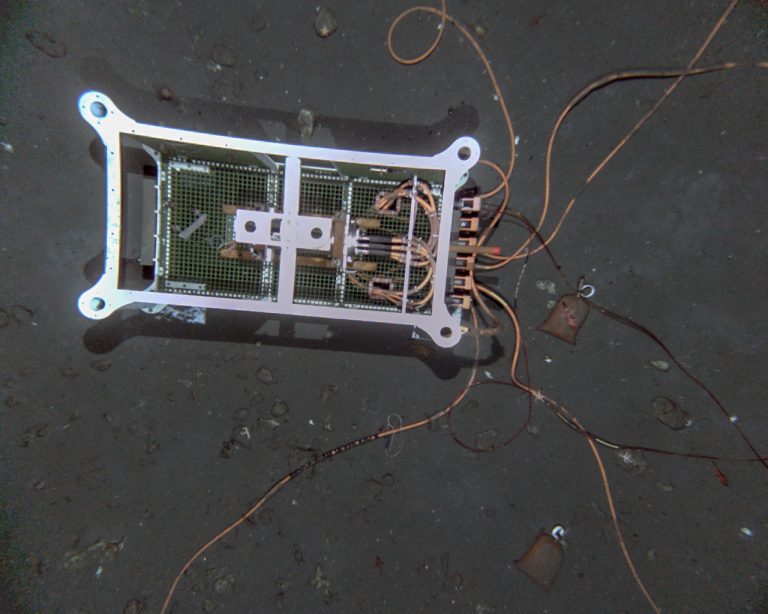
Marissa is very aware of the potential of these images, once they reach the public. “When I first saw those images of the seabed, I said to Dr. Thornton ‘I think people often see the ocean as something so endless that if you throw something into it, it’s just “gone”.’ It is out of sight out of mind – not a problem anymore. But we send these cameras down and you can see that’s just not the case.” There in the remoteness of the seafloor, the presence of man is still visible.
“It is important to bring the seabed closer to people, because I think it can be easy to disregard where this rubbish is going. Take for instance the fishing gear that we’re seeing down there. I think more people should see that not only are we littering the beaches and creating the floating ‘plastic islands’ in the Pacific, but we are littering the seabed too. It has been very eye opening,” she reflects.
After having driven SuBastian with such a clear understanding of its surroundings, Adam’s mind is set. “I wish these guys were on board for all our dives and could give us such great information before we’re on the bottom”.
That is perhaps one of the aspects on Dr Thornton’s mind when he says we have to stay aware of the bigger picture: looking beyond the single deployment or single cruise. “It is really a journey. This doesn’t end the moment we step off the ship,” he says.