Perspectivas sobre la conectividad del área de estudio, a nivel regional, entre la columna de agua y el fondo marino, implicaciones para la gestión e investigación.
English Translation Below
“Todo está conectado”…. Una frase muy trillada que aplica de manera perfecta para lo que sucede en el océano, un medio que obedece las leyes de la física y la dinámica de fluidos.
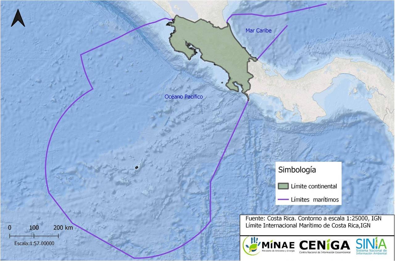
Mar adentro en el Océano Pacífico encontramos muchos ejemplos de cómo la física explica no solamente las principales corrientes marinas sino también la conectividad que puede existir entre los diferentes países que comparten recursos oceánicos transfronterizos. Justamente esta es una de las razones que nos trae en esta ocasión a navegar las aguas del Pacífico costarricense a bordo del buque R/V Falkor (too); ya que uno de nuestros objetivos principales en esta expedición es entender mejor la asociación que existe entre la columna de agua y el fondo marino que yace en promedio a más de 3000 metros de profundidad (Figura 1).
Para entender estas asociaciones se complementan dos ramas científicas: la hidrografía, que es el estudio y descripción de los cuerpos de agua, así como de sus características físicas y químicas, y la oceanografía física, que está estrechamente relacionada con la hidrografía. La oceanografía física se enfoca en estudiar y validar los procesos físicos del océano, como corrientes, olas y circulación. La hidrografía proporciona datos para comprender la oceanografía física, incluyendo características del agua, dinámica de las corrientes y distribución de masas de agua. Ambas disciplinas son cruciales para comprender y gestionar nuestros océanos y mares.
Entender las corrientes marinas no solamente nos permite entender la conectividad física de las masas de agua en una zona determinada sino que también nos dan un vistazo a la conectividad biológica, principalmente debido a que muchas especies marinas cuentan con una fase larval durante la cual derivan con las corrientes.
Todo esto nos trae al área de estudio, mar adentro de la costa Guanacasteca. Para entender la conectividad de esta zona, es importante entender el contexto donde se encuentra la Zona Económica Exclusiva de Costa Rica, la cual está en una región conocida como el Pacífico Tropical Oriental Norte (Figura 2). La circulación del océano en esta zona está determinada principalmente por la interacción de corrientes geostróficas con la plataforma continental de Centroamérica y los vientos que se canalizan a través de las interrupciones en el sistema montañoso. Así mismo, la posición de la Zona de Convergencia Intertropical (ITCZ) la cual es una franja cerca del ecuador donde los vientos alisios del hemisferio norte y sur se encuentran y ascienden, generando una región de alta convección y precipitación intensa.
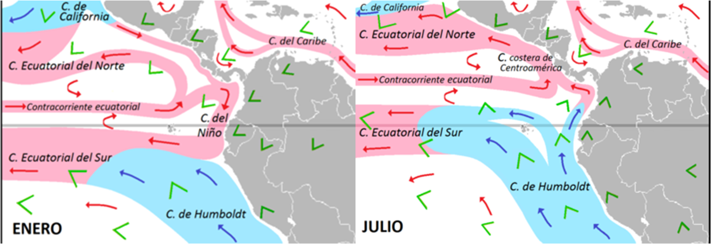
Las corrientes geostróficas son corrientes marinas constantes generadas por el equilibrio entre la fuerza de Coriolis y la fuerza de gradiente de presión. Desvían el movimiento del agua debido a la rotación de la Tierra y el flujo de presión. Son cruciales para el transporte de calor, nutrientes y tienen un impacto en el clima y la circulación oceánica global. En nuestra área de estudio en el Pacífico costarricense, las principales corrientes geostróficas presentes son la Contra Corriente Ecuatorial Norte (NECC), que fluye de oeste a este y la Corriente Costera de Costa Rica (CRCC), que fluye pegada a la costa en dirección sureste-noroeste, esta última aún con pocas observaciones que validen su estacionalidad y persistencia internaual.
Estudios previos indican que cuando la NECC interactúa con la plataforma continental, se desvía en dos flujos opuestos hacia el norte y sur. Del brazo sur se conoce poco, no obstante del brazo que se extiende hacia el norte se tiene evidencia básica que interactúa con la CRCC incluso contribuyendo al origen de la misma, lo cual aún no se termina de determinar. Así mismo, debido a la fuerza de rotación de la Tierra y el momentum que trae la NECC, en ocasiones la conservación de la vorticidad potencial contribuye a la presencia de una característica muy importante en nuestra área de estudio conocida como el Domo Térmico de Costa Rica (CRTD).
El CRTD es un afloramiento off-shore que resulta de la interacción de todos los factores mencionados anteriormente, el cual a su vez tiene una variación estacional, originándose en el primer trimestre del año en cercanías de la costa de Costa Rica y fuertemente influenciado por el afloramiento costero de Papagayo, que es producto de los vientos del noreste que se canalizan a través de la interrupción del sistema montañoso asociado al Lago de Nicaragua. Conforme el año avanza y la ITCZ se mueve hacia el norte, los vientos de Papagayo disminuyen y el CRTD se despega de la costa y extiende su área de influencia hacia el noroeste, donde influye en la dinámica de las ZEEs de los países centroamericanos y gran parte del altamar o las aguas internacionales (ABNJ). Esto es de gran importancia ya que el CRTD promueve una alta productividad primaria que tiene dos efectos principales con respecto a esta expedición: en primera instancia promueve la productividad pesquera en aguas superficiales y por ende es un objeto de interés de gobernanza transfronterizo y, en segunda instancia, la mayoría de la productividad que se genera en la superficie eventualmente termina hundiéndose hacia el fondo marino, en este caso, gran parte en nuestra área de estudio en el montículo rocoso del Dorado a más de 3000 metros de profundidad.
Poco se sabe sobre lo que sucede con toda esta materia orgánica que se hunde hacia las profundidades y esto es uno de los objetivos de esta expedición, entender cuál es la relación entre el CRTD y el fondo marino en esta zona, así como determinar la circulación en toda la columna de agua. De las cosas que sí se saben es que estas aguas albergan una alta cantidad de biomasa planctónica, compuesta principalmente por organismos que derivan en la columna de agua. Esto también se asocia a otra característica que estamos estudiando en esta expedición, la Zona de Mínimo Oxígeno (OMZ), la cual es una capa de agua con bajas concentraciones de oxígeno que usualmente se ubica entre los 300m y los 800m de profundidad, producto de la poca ventilación de corrientes y la actividad metabólica asociada a los microbios que degradan la materia orgánica que desciende lentamente hacia el abismo, agotando el oxígeno hasta un punto en donde incluso se tienen capas prácticamente anóxicas, osea, desprovistas de oxígeno (Figura 3).
Todo esto es objeto de estudio en esta expedición donde estamos complementando las observaciones del fondo marino que se toman con el ROV SuBastian, con diferentes instrumentos que se encuentran a bordo tales como el CTD, el sistema de ecosonda sonar EK80 y correntímetros acústicos tipo ADCP. A partir de esta información no solamente podemos entender lo que sucede en la columna de agua sino que también podemos identificar las masas de agua presentes en la zona, lo cual nos puede dar pistas de la conectividad a nivel regional y entender mejor el acoplamiento pelágico-bentónico.
Parte de las observaciones que hemos obtenido en nuestra primera semana de muestreo, nos indican una presencia de una masa de agua ecuatorial pegada a la costa, lo cual indica una fuerte influencia de aguas que se encuentran más hacia el sur de Costa Rica. Esta señal fue detectada en nuestra primera estación de muestreo y hemos visto como se ha disipado mientras nos desplazamos hacia el oeste. Así mismo, hemos podido ver que el núcleo de la OMZ es más grueso en el área de estudio en comparación con la estación de control en la costa, observaciones que nos servirán en el futuro para entender más sobre la dinámica de esta zona y posibles efectos que pueda tener el cambio climático.
Finalmente, seguiremos muestreando con los instrumentos mencionados, en puntos estratégicos que se distribuyen en una grilla para poder generar interpolaciones de la zona de estudio, y tener una línea base de la hidrografía tanto en superficie como en el fondo. Así mismo, utilizaremos todos estos datos para demostrar la importancia de establecer estos vínculos entre la superficie y las profundidades, con la esperanza y determinación de que en un futuro –no muy lejano- servirán para establecer medidas de conservación efectivas.
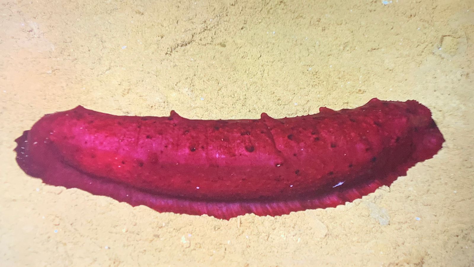
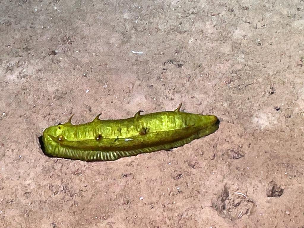
Llegamos a esta expedición con muchas preguntas que serán respondidas por los datos que tomamos, no obstante, no tenemos la menor duda que saldremos con el triple de preguntas y esto es lo bonito de la ciencia. Por ejemplo, algunas de las preguntas que han surgido son, qué tanta conectividad hay entre esta zona y la zona de Clarion Clipperton, puesto que se ve mucha similitud en la composición de fauna bentónica. En este sentido, existe también la incógnita de qué tanto dependen las especies del fondo del aporte de la nieve marina (partículas que se hunden desde la superficie), ya que hemos visto muchos pepinos de mar que usualmente son indicadores de altos contenidos de materia orgánica en los sedimentos (Figura 5). Estas y otras preguntas, permanecen aún sin respuesta…
Mientras escribo estas palabras, lucho por contener las lágrimas de felicidad de poder estar viviendo esta experiencia, es mucha la emoción cada vez que tengo la oportunidad de estar en altamar, pero esta vez es especial, ya que es la primera vez que me sumo a una expedición de fondos marinos profundos en mi país que tanto amo… hace 15 años cuando decidí dedicar mi vida a estudiar y proteger el océano nunca me hubiera imaginado que esto se haría realidad a mis 30 años y mucho menos con un grupo de personas tan apasionadas por la ciencia y la conservación. Tengo la certeza de que el trabajo que se está realizando logrará que las personas en Costa Rica se identifiquen más con nuestro patrimonio profundo… que cuando vayan a la playa y vean el horizonte, tengan la certeza de que ahí abajo yace nuestro mayor tesoro y que el mundo entero sepa que en Costa Rica llevamos el Pura Vida bien profundo.
Everything is Connected
Perspectives on the connectivity of the study area, at the regional level, between the water column and the seabed, implications for management and research.
“Everything is connected”… A very cliché phrase that perfectly applies to what happens in the ocean, a medium that obeys the laws of physics and fluid dynamics. In the deep sea of the Pacific Ocean, we find many examples of how physics explains not only the major ocean currents but also the connectivity that can exist among different countries sharing transboundary oceanic resources. This is precisely one of the reasons that brings us on this occasion to navigate the waters of the Costa Rican Pacific aboard the R/V Falkor (too); as one of our main objectives on this expedition is to better understand the association between the water column and the seafloor that lies on average over 3000 meters deep (Figure 1).
Figure 1. Bathymetric map of Costa Rica’s Exclusive Economic Zone. Credit: MINAE
To understand these associations, two scientific branches complement each other: hydrography, which is the study and description of bodies of water, as well as their physical and chemical characteristics, and physical oceanography, which is closely related to hydrography. Physical oceanography focuses on studying and validating the physical processes of the ocean, such as currents, waves, and circulation. Hydrography provides data to understand physical oceanography, including water characteristics, current dynamics, and water mass distribution. Both disciplines are crucial for understanding and managing our oceans and seas. Understanding ocean currents not only allows us to understand the physical connectivity of water masses in a given area but also gives us a glimpse into the biological connectivity, mainly because many marine species have a larval phase during which they drift with the currents.
All of this brings us to the study area, offshore of the Guanacaste coast.
To understand the connectivity of this zone, it is important to understand the context in which Costa Rica’s Exclusive Economic Zone is located, which is in a region known as the Eastern Tropical Pacific (Figure 2). The ocean circulation in this zone is primarily determined by the interaction of geostrophic currents with the continental shelf of Central America and the winds channeled through interruptions in the mountain system. Similarly, the position of the Intertropical Convergence Zone (ITCZ), which is a belt near the equator where the trade winds from the northern and southern hemispheres meet and ascend, generating a region of high convection and intense precipitation.
Figure 2. Simplified scheme of the main geostrophic currents in the Eastern Tropical Pacific
Geostrophic currents are constant ocean currents generated by the balance between the Coriolis force and the pressure gradient force. They deflect the movement of water due to the rotation of the Earth and the pressure flow. They are crucial for the transport of heat, nutrients, and have an impact on climate and global ocean circulation. In our study area in the Costa Rican Pacific, the main geostrophic currents present are the North Equatorial Counter Current (NECC), which flows from west to east, and the Costa Rica Coastal Current (CRCC), which flows along the coast in a southeast-northwest direction, the latter still with few observations to validate its seasonality and interannual persistence. Previous studies indicate that when the NECC interacts with the continental shelf, it splits into two opposing flows to the north and south. Little is known about the southern branch; however, there is basic evidence of the interaction between the northern branch and the CRCC, even contributing to its origin, which is still being determined. Likewise, due to the Earth’s rotational force and the momentum brought by the NECC, the conservation of potential vorticity occasionally contributes to the presence of a very important feature in our study area known as the Costa Rica Thermal Dome (CRTD).
The CRTD is an offshore upwelling resulting from the interaction of all the factors mentioned above, which in turn has a seasonal variation, originating in the first quarter of the year near the coast of Costa Rica and strongly influenced by the coastal upwelling of Papagayo. The Papagayo upwelling is a result of the northeast winds channeled through the interruption of the mountain system associated with Lake Nicaragua. As the year progresses and the ITCZ moves northward, the Papagayo winds diminish, and the CRTD separates from the coast and extends its area of influence towards the northwest, where it influences the dynamics of the Exclusive Economic Zones (EEZs) of Central American countries and a large part of the high seas or international waters (ABNJ). This is of great importance as the CRTD promotes high primary productivity, which has two main effects regarding this expedition: firstly, it promotes fisheries productivity in surface waters and, therefore, is an object of interest for transboundary governance. Secondly, most of the productivity generated on the surface eventually sinks to the seafloor, in this case, a significant portion in our study area on the rocky mound of Dorado at depths exceeding 3000 meters.
Little is known about what happens to all this organic matter that sinks to the depths, and this is one of the objectives of this expedition: to understand the relationship between the CRTD and the seafloor in this area, as well as to determine the circulation throughout the water column. One thing that is known is that these waters harbor a high amount of planktonic biomass, mainly composed of organisms that drift in the water column. This is also associated with another characteristic we are studying in this expedition, the Oxygen Minimum Zone (OMZ), which is a layer of water with low oxygen concentrations that usually occurs between 300 meters and 800 meters deep. It is the result of poor ventilation by currents and the metabolic activity associated with microbes that degrade the slowly descending organic matter, depleting the oxygen to the point where there are even practically anoxic layers, meaning devoid of oxygen (Figure 3).
Figure 3. Simplified scheme of the Costa Rica Thermal Dome (CRTD), coastal upwelling of Papagayo, and Oxygen Minimum Zone (OMZ).
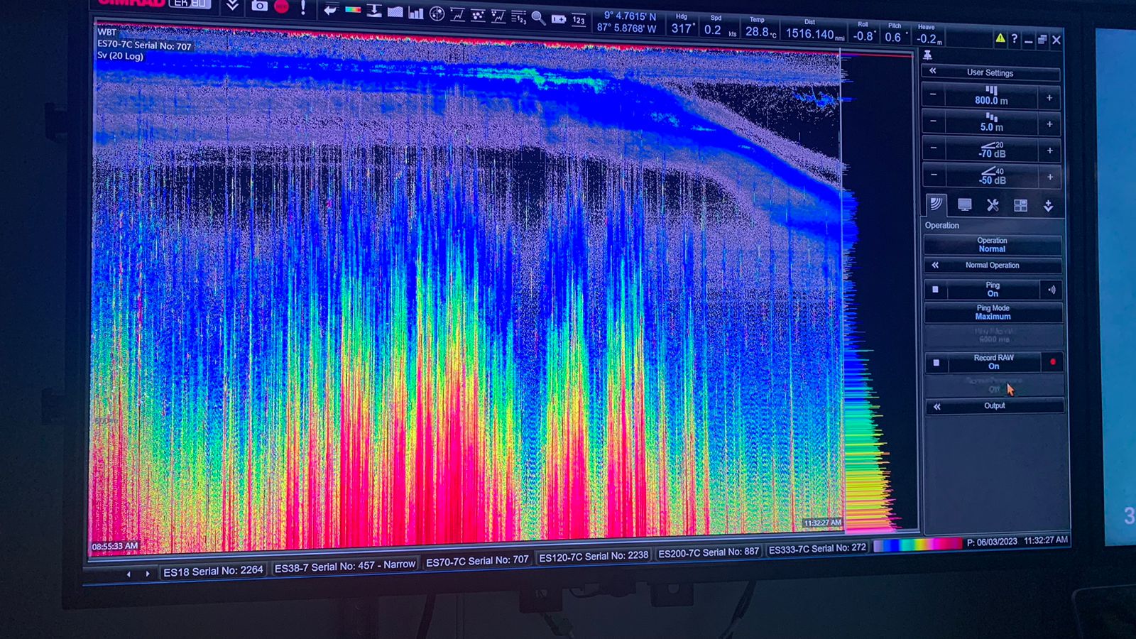
All of this is the subject of study in this expedition, where we are complementing the observations of the seafloor taken with the ROV SuBastian with different instruments on board, such as the CTD, the EK80 sonar echosounder system, and acoustic Doppler current profilers (ADCP). With this information, we can not only understand what happens in the water column but also identify the water masses present in the area, which can give us clues about regional connectivity and a better understanding of pelagic-benthic coupling. Part of the observations we have obtained in our first week of sampling indicate the presence of an equatorial water mass near the coast, indicating a strong influence of waters found further south of Costa Rica. This signal was detected at our first sampling station and we have seen it dissipate as we move westward. Likewise, we have observed that the core of the OMZ is thicker in the study area compared to the control station on the coast. These observations will help us understand more about the dynamics of this zone and possible effects of climate change.
Figure 4. EK80 echosounder data showing the vertical migration of zooplankton.
Finally, we will continue sampling with the mentioned instruments at strategic points distributed in a grid to generate interpolations of the study area and establish a baseline of the hydrography both on the surface and the seafloor. We will use all this data to demonstrate the importance of establishing these links between the surface and the depths, with the hope and determination that, in the not-so-distant future, they will contribute to establishing effective conservation measures. We embarked on this expedition with many questions that will be answered by the data we collect. However, we have no doubt that we will come back with three times as many questions, and that is the beauty of science. For example, some of the questions that have arisen are: how much connectivity exists between this area and the Clarion-Clipperton Zone, considering the similarity in benthic fauna composition? In this regard, there is also the question of how much the benthic species depend on the input of marine snow (particles sinking from the surface), as we have observed many sea cucumbers, which are usually indicators of high organic matter content in the sediments (Figure 5). These and other questions still remain unanswered…
Figure 5. Some sea cucumbers (Holothurians) we have seen in the study area. These animals are indicators of high organic matter content in the sediment.
As I write these words, I struggle to hold back tears of happiness at being able to live this experience. The excitement is overwhelming every time I have the opportunity to be at sea, but this time is special because it is the first time I have joined an expedition to explore deep-sea environments in my beloved country. When I decided to dedicate my life to studying and protecting the ocean 15 years ago, I never imagined that this would become a reality at the age of 30, let alone with a group of people so passionate about science and conservation. I am certain that the work being done will make Costa Ricans feel more connected to our deep-sea heritage. When they go to the beach and see the horizon, they will know that our greatest treasure lies beneath, and the whole world will know that in Costa Rica, we embrace the “Pura Vida” spirit even in the depths.