At the time I’m writing this blog post, Research Vessel Falkor has set off from Vietnam and we are now in the middle of the South China Sea. I stood on the top deck this morning as the sun came up and marveled at the utter uniformity of the solid horizon line that completely encircled us. I’ve never been at sea before, so this experience is deeply strange to me. Nowhere I’ve ever been – not even the flattest part of Kansas or the most central part of the Bonneville Salt Flats – has been so crushingly expansive or disorienting.
Early Maps
Inside the ship, I’ve continued to be mesmerized by maps of the ocean floor, and have read up a little bit on their history. Seafloor mapping (a field in which Falkor now plays an important role) is strangely new. For millennia the oceans concealed an utterly unknown landscape, and it was only the development of sonar technologies to hunt for submarines during World War II that enabled the process of charting this part of the planet at all. As recently as the early 1950s, it was generally assumed that the seafloor basically consisted of vast expanses of sandy muck.
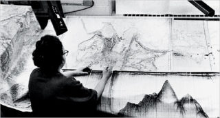
The first person to physically map the details of the ocean floor on a global scale was Marie Tharp, who with her colleague Bruce Heezen published several maps showing different parts of the sea floor throughout the 1950s and 60s. The first, a map of the North Atlantic, appeared in 1952. To render these maps, Tharp would sit for hundreds of hours at a huge drafting table and painstakingly interpret data sets that Heezen had amassed using thousands and thousands of sonar pings on his various research expeditions across the world’s oceans. (One consequence of the infuriating and ridiculous social mores in place during the midcentury was that as a woman, Tharp wasn’t physically allowed on a research vessel at the time.)
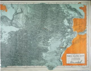
The maps were as groundbreaking as they were beautiful: they were the first to depict such features as the Equatorial Mid-Ocean Canyon, the towering Mid-Atlantic Ridge, and the glaring rift valley that runs the entire 40,000-mile length of that mountain range. As a result, the charts suddenly provided the scientific community with nearly incontrovertible evidence for the then-controversial theories of continental drift and plate tectonics. They thereby literally altered our understanding of the world.
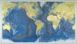
In 1977 the fruits of the twenty-five year collaboration between Tharp and Heezen were all gathered together in the stunning World Ocean Floor Panorama. The map was painted by the Austrian artist H.C. Berann, best known for his distinctive birds-eye-view paintings of national parks and other impressive landscapes (Berann had begun working with Tharp and Heezen in the late 1960s, after his young daughter wrote to National Geographic to inform them that her father could paint better mountains than any of their artists). Sadly, shortly after approving the first printer’s proofs of the Panorama, Heezen died of a heart attack in a submarine off the coast of Iceland; Tharp would spend the next thirty years archiving and cataloguing their work together.
Back to the Present
Despite its massive contribution to one of the most significant paradigm shifts in the history of geology, Tharp’s work was somewhat bewilderingly underappreciated for decades. National Geographic even passed on publication of the World Ocean Floor Panorama because, paradoxically, the theories of continental drift and plate tectonics had become so widely accepted so quickly that by the late 1970s the world-changing ideas depicted in the map already seemed unremarkable. It was published instead by the U.S. Office of Naval Research. Tharp has finally gained some well-deserved public notoriety in recent years: she has been the subject of a handful of magazine, newspaper, and radio features since her death in 2006, and Soundings, a long, wide, and lyrical book by American author Hali Felt about Tharp and her work, was released in 2012. A children’s book about her came out earlier this year.

At the moment, I’m especially grateful for the added perspective provided by maps like Tharp’s. It’s enormously strange to try and orient oneself within an environment like the one I would see from the deck if I were to run up there right now: any sense of scale I can muster from here could be derived only from the gigantic freighters that pass and by a rough assessment of how quickly the sizes of the ripples and swells around us recede into the distance. It’s stranger still to look at a map like this and remember that by stepping onto this ship in the port, I merely arranged to keep myself at an altitude of 0 feet: the land just got lower, and we floated above it. It’s remarkable and weirdly edifying to know that those canyons and peaks lie distantly beneath us, even when all I can see in any direction is unyieldingly flat, blue, and bright.