Imaging the K-T Boundary

Seafloor mapping continues

Schmidt Ocean Institute
Mar. 14 2013
This image depicts three different sounding methods. Sailors would use a lead line when coming into port to keep an eye on how shallow the water was getting and what type of bottom material it was. Single beam sonars increased coverage of soundings along the track of the vessel, and multibeam sonars increase the soundings both along track and across track. Modern survey vessels can cover a lot more (ocean) ground.
This image depicts three different sounding methods. Sailors would use a lead line when coming into port to keep an eye on how shallow the water was getting and what type of bottom material it was. Single beam sonars increased coverage of soundings along the track of the vessel, and multibeam sonars increase the soundings both along track and across track. Modern survey vessels can cover a lot more (ocean) ground.NOAA

Mapping of Campeche Escarpment reminds us that hydrographic surveys may not be as ‘glorious’ as some other types of ocean research, such as, for example, ROV operations, however, seafloor maps are extremely important for all ocean disciplines.  ROV pilots won’t dive these days without seeing a map of the site first.

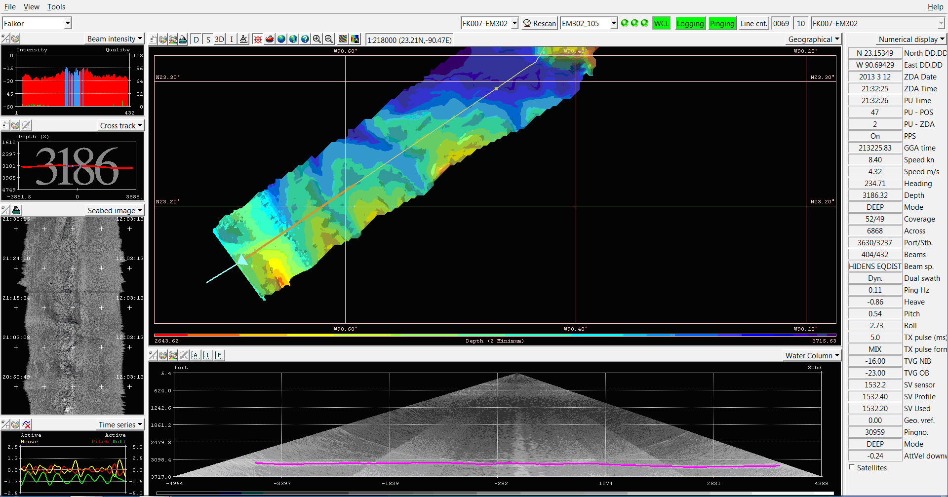
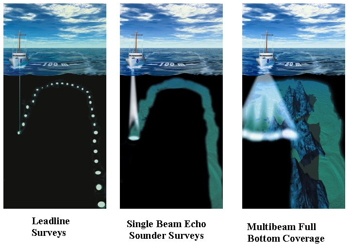
Satellite maps available for Campeche Escarpment, although better than nothing, leave a lot to be desired for knowing what the seafloor topography here really looks like.  Other previous data sets include single-beam data: it only characterizes the depth of the seafloor along a narrow track of the survey ship, only leaving a pencil-width surveyed track on the map.  R/V Falkor’s EM302 multibeam echo sounder works more like a paintbrush.  It uses a fan of acoustic beams to survey a much wider path which allows R/V Falkor to map a significantly larger area in less time, greatly increasing the efficiency of the survey.

Various features that R/V Falkor’s multibeam system may detect along the escarpment, including canyons and ridges, provide habitats for a variety of species and contain a geologic record of the area.  These data will be investigated in detail and used in the future to plan follow-up targeted research projects in this area, involving Autonomous Underwater Vehicles (AUV) for even higher resolution localized mapping of the escarpment and Remotely Operated Vehicles (ROV) for in-situ sampling and visual observations.

This screenshot image of R/V Falkor EM302 multibeam echo sounder data processing software shows canyons and ridges extending from the Campeche Escarpment.  This is the first mapping pass of R/V Falkor along the base of the Escarpment, and this data will determine where the ship will operate as it traverses the Escarpment in the opposite direction.
This screenshot image of R/V Falkor EM302 multibeam echo sounder data processing software shows canyons and ridges extending from the Campeche Escarpment. This is the first mapping pass of R/V Falkor along the base of the Escarpment, and this data will determine where the ship will operate as it traverses the Escarpment in the opposite direction.Schmidt Ocean Institute

Share This