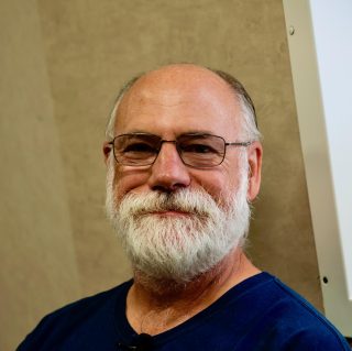
David Caress is a Principal Engineer at MBARI who leads the institute’s efforts to develop seafloor mapping technology. At MBARI since 1998, he proposed and co-led the development of the Autonomous Underwater Vehicles (AUVs) being used for 1 meter scale mapping on this expedtion, and more recently leads a team developing capabilities for mapping and imaging the seafloor at 1 centimeter scale. Originally trained in marine geophysics at the Scripps Institution of Oceanography, Caress began developing seafloor mapping data processing techniques and software at the Lamont-Doherty Earth Observatory and continued this work while employed in industry. Since 1993 he has been the principal author of MB-System, an open source software package for the processing and display of seafloor mapping data.
Cruises: