Today’s work was a study in classic oceanography that took the team to the source of the lower-oxygen water that is the focus of the expedition—and it all came with some beautiful views. There are more and more whale sightings, and albatross are constantly skimming the surface of the waves, which remain reasonably calm.
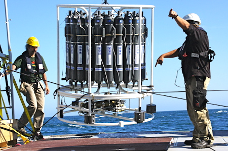
During the early morning hours, the team headed offshore into the deeper reaches of Barkley Canyon, just south of the NEPTUNE Barkley node. By breakfast, they had made it to the expedition’s deepest, most distant station, called La Perouse C-Line, or LC12. It took nearly three hours to do one full CTD cast, dropping the rosette all the way to the bottom some 2,460 meters down and then winching it back.
We’ve found our source, and now we’ll follow it as best we can. – Richard Dewey
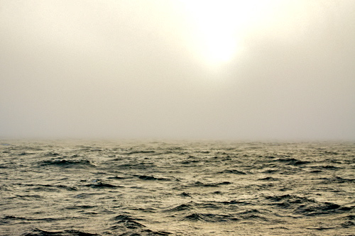
At the surface this far out the water looks very different from the darker water closer to shore in the Salish Sea. Out here, the water is crystal clear and a cobalt blue. You might expect the waters to be colder, but they are not. The upwelling processes that send deeper waters toward shore also transport relatively warmer (17°C/62°F) coastal waters offshore.
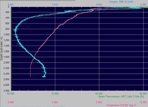
LC12 is fairly representative of what’s found throughout the Northeast Pacific, and it illustrates textbook oceanography. The graphic to the right gives you an idea of what the team is seeing. The temperature line is pink, and the oxygen line is blue. The temperature mostly drops as you go deeper with a bit of a blip at the 200-meter level that’s called the mixed layer.
The oxygen tells a more interesting story. It too drops steadily as you go deeper, but only for a while. It hits its minimum in the 700 to 900-meter depth range. And it’s quite low throughout the range from 400 to 1,600 meters down. This is an oxygen minimum zone (OMZ) and it’s the starting point for everything the team is out to study.
Even in the deep sea, there’s really only one source for free oxygen—photosynthesis. Phytoplankton in the surface waters produce oxygen, and land plants add oxygen to the atmosphere that can diffuse into the ocean. Oxygen makes its way into the depths by very slow processes, so it can get used much more quickly than it is replenished, leading to formation of OMZs.
The main oxygen consumers are fish, and bacteria that use oxygen when chomping on dead organic material that rains down from above. An OMZ is a layer where this activity is most pronounced. Amazingly, deeper waters in the North Pacific where the team is working got most of their oxygen when that water was at the surface and exposed to air in the North Atlantic centuries ago. There it sank and made its way slowly to the Pacific along a deepwater current path that’s part of what’s called the Global Conveyor Belt.
Very little oxygen from waters above diffuses down, so the fish and bacterial oxygen consumption has a cumulative effect. Fish and bacteria also process complex hydrocarbons into simple nitrates, phosphates and silicates that are essential nutrients for marine life.
So, the water in this layer 400 to 600 meters down is deep, cold, salty, low in oxygen, and rich in nutrients, and it’s exactly the water the team came to track. “We’ve found our source, and now we’ll follow it as best we can,” says Richard Dewey.
The marathon of CTD rosette casts nearly complete, the team will begin working with the Moving Vessel Profiler. The tracks they’ll follow with the MPV will be guided by what they’ve been seeing in the data coming back from the CTD sensors and water samples. Working with the MVP will mean a change of pace, and sampling gear that requires less crew support, a switch that will give most everyone a welcome break.